San Dieguito Field – Del Mar Naval Auxiliary Air Facility
Last revision of this page: March 1, 2025

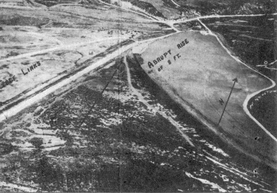
The Del Mar Airfield, as depicted on the 1929 U.S. Navy Aviation Map (courtesy of Roger Connor). This property was first used as an airfield in the 1920s, when the Navy established an emergency landing field known as the San Dieguito Field (according to the Friends of the San Dieguito River Valley web site). The earliest depiction which has been located of Del Mar Airfield was an undated aerial view from the 1929 U.S. Navy Aviation Map (courtesy of Roger Connor). The chart described Del Mar as “Field, very short”. The Del Mar Airfield property was believed to have been developed in 1938 as a municipal airport to serve the racing patrons at the new Del Mar Fairgrounds. The airport included a 3,500' runway & several support buildings. In 1941, the Navy purchased 80 acres at the site with the intention of building an improved airfield with 2 paved runways. However, the planned paved runways were not constructed as the cost of building a dike to prevent flooding on the site proved prohibitive, and the facility was eventually used as a blimp base instead. After Pearl Harbor, fairs & racing at the nearby Del Mar Fairgrounds were suspended, and the Navy used the fairgrounds & racetrack as barracks, galleys, mess halls, offices, recreational facilities and classrooms for Navy personnel stationed at the Del Mar airfield during the war.

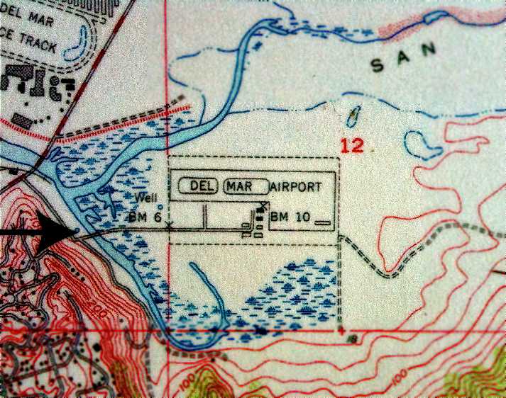
The Del Mar airfield was depicted simply as a rectangular area labeled “Emergency Landing Field” on the 1943 USGS topo map. Starting in 1943 the US Naval Auxiliary Air Facility Del Mar was used as a base for blimps which conducted anti-submarine patrols along the west coast. The airfield consisted of a 1,000' x 500' asphalt blimp landing mat with 2 mooring circles. Other military construction included 6 buildings & 5 ordnance magazines. Barracks were provided for a total of 138 personnel.

A 1943 aerial view looking west at Del Mar NAAF (National Archives photo). Usually only 2 blimps operated from the Del Mar field at one time since there were only 2 mooring masts. They were refueled at Del Mar & then continued anti-submarine patrols up & down the coast and as much as 100 miles out to sea. The blimps operated from Del Mar were K-types assigned to the blimp squadron ZP-31 based at the Santa Ana Naval Air Station. The K-type blimps were 252' in length, able to lift 7,770 pounds, and boasted a maximum speed of 68 knots.
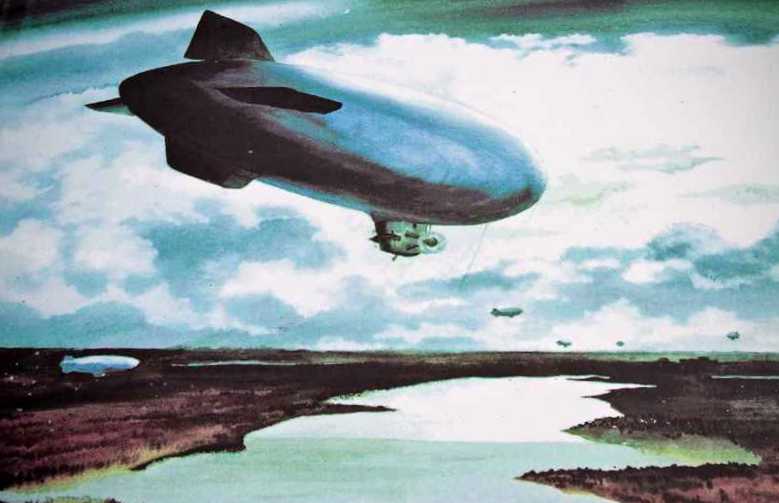
A painting by Adolph Dehn (courtesy of Mark Dossett) of blimps heading out from Del Mar NAAF. In 1944, MGM Studios used the blimp base to film portions of the movie "This Man's Navy". One of Del Mar's blimps crashed on Santa CatalinaIsland in 1944, causing 5 fatalities. "NAAF Del Mar (LTA)" was described by the 1944 US Army/Navy Directory of Airfields (courtesy of Ken Mercer) as having a 1,000' hard-surface runway. The remarks said "Rectangular asphalt mat & paved mooring circles adjacent."
The Del Mar Naval Auxiliary Air Facility was decommissioned in 1945 and the fairgrounds & racetrack were returned to the State of California.
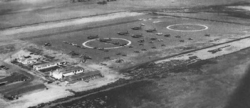
An undated (circa 1940s) aerial view looking northeast at NAAF Del Mar, showing no less than 42 aircraft present on the field, including 6 twin-engine DC-3s/C-47s/R4Ds. The photo is from a historical sign at the site of the airfield, photographed by Chris Kennedy in 2006.
The 1945 AAF Airfield Directory (courtesy of Scott Murdock) described Del Mar NAAS as an 80 acre rectangular property having a 1,000' east/west asphalt landing mat & 2 paved circles. The field was not said to have any hangars, to be owned by the U.S. Government, and operated by the Navy.
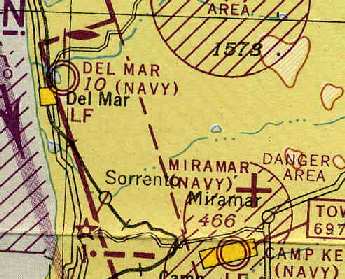
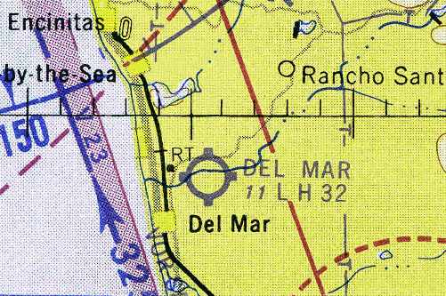
"Del Mar (Navy)", as depicted on the 1945 San Diego Sectional Chart (courtesy of Chris Kennedy). With the end of WW2, Del Mar NAAF was closed in 1945. However, the March 1946 San Diego Sectional Chart (courtesy of Chris Kennedy) continued to depict “Del Mar (Navy)” as a military airfield. A June 1946 Department of Commerce Airman's Guide (according to Chris Kennedy) described “Del Mar NAAF” as “No longer assigned to Navy. Will hereafter be carried as Del Mar Airport”, as of May 27, 1946. The Navy retained ownership of the airfield until 1947, when the 80 acres were quitclaimed to the County of San Diego for $1. A 2,500' runway was established for fixed-wing aircraft, and the field was reused it as a civil airfield, the Del Mar Airport. The airport also featured a popular restaurant, patio, and lounge. Del Mar Airport was used frequently by visitors to the nearby Del Mar Hotel & racetrack.

An undated (circa late 1940s?) advertisement for Pacific Southwest Airlines DC-3 service from Burbank to the Del Mar Airport (courtesy of the PSA History Museum). Former WW2 Marine pilot James “Skeets” Coleman oversaw the operation of Del Mar Airport from 1948-50.

The last photo which has been located showing Del Mar Airport while it was still in operation was an undated aerial view looking north from the 1950 Air Photo Guide (courtesy of Kevin Walsh). The guide described Del Mar Airport as having a 2,600' paved Runway 8/26, and listed the manager as James Coleman. The March 1951 San Diego USAF Sectional Chart (courtesy of Chris Kennedy) depicted the Del Mar Airport as having a 2,500' unpaved runway. In 1952 the old airport buildings were leased to a young Del Mar engineer, Andrew Kay, who started Non-Linear Systems, initially producing digital voltmeters. Work at NLS eventually led to the production of the "Kaypro", one of the first home computers.
The 1953 USGS topo map (courtesy of Mark Dossett) depicted the Del Mar Airport as having a single east/west paved runway, with a parallel taxiway, a ramp on the southeast corner, and a total of 7 small buildings.

The 1953 Southern California Flight Chart (courtesy of Scott O'Donnell) depicted Del Mar Airport as having a 2,500' hard surface runway. Del Mar Airport was listed among active airfields in the "Aerodromes" table on the 1955 San Diego Sectional Aeronautical Chart (courtesy of John Voss). It described the field as having a single 2,500' bituminous runway.
The last aeronautical chart depiction which has been located of the Del Mar Airport was on the September 1959 San Diego Sectional Chart (courtesy of Chris Kennedy). It depicted the Del Mar Airport as having a 3,200' hard surface runway. Unfortunately the Del Mar Airport was closed in 1959, and the property was transferred to the State as part of the right-of-way for the the new Interstate 5. A big white “X” was displayed on the runway, indicating the closure of the field (according to a historical sign at the site of the airfield, photographed in 2006 by Chris Kennedy). Interstate 5 was eventually built through the eastern portion of the Del Mar Airport property. By the time of the September 1961 San Diego Local Aeronautical Chart (courtesy of Chris Kennedy) the former Del Mar Airport was depicted as “Abandoned Airport” (even though the new freeway which caused its closure was not yet depicted at all).
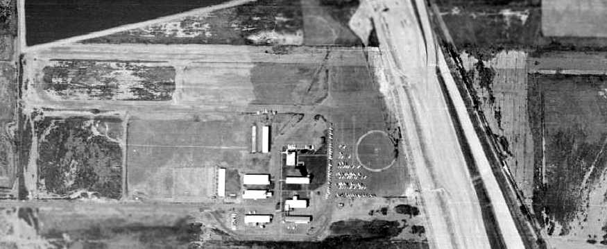
A 1964 aerial view showed the site of the Del Mar Airport, with the newly-built Interstate crossing right over the eastern portion of the runway & ramp.The airport was otherwise still intact, with one blimp circle still visible, the runway & parallel taxiway still intact, and all of the airport buildings still standing. Non-Linear Systems continued to operate from the former barracks on the western side of the Del Mar Airport property until 1968, when it relocated to Solana Beach. A 1980 aerial photo shows that the former Del Mar Airport buildings were removed at some point between 1964-80.

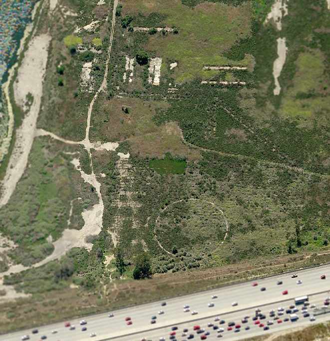
The site of the Del Mar Airport, as seen in the 1994 USGS aerial photo. Amazingly, by comparing this with the aerial photos from previous years, it may be seen that the remains of the western blimp mooring circle are still barely evident, right next to the western side of Interstate 5. The foundations of the airfield buildings are also still evident, in the same layout as in the picture from 51 years before.
Incredibly, a circa 2006 aerial photo looking west at the site of Del Mar Airport shows that the blimp mooring circle & foundations of the airfield buildings were still evident, 47 years after the airport was abandoned. Josh Neubauer reported in 2006, “The foundations & blimp mooring circle of the Del Mar Airport are being torn up for the San Dieguito Lagoon Restoration project. It was interesting seeing the well-defined outlines of the shallow holes where each structure once stood.” Unfortunately, John Voss reported of the former Del Mar airfield in 2007, “It's gone. There were a number of earth movers, bulldozers & scrapers moving about the entire area making a lot of dust. They appear to be preparing the area for home sites... or possibly another golf course! This activity was all to the west of Interstate 5. I would imagine that there is a bit of runway remaining to the east of the highway but due to excessive weed growth nothing could be observed.” A 2008 aerial photo shows that the majority of the former airport property (on the west side of the freeway) has now been flooded. The only remaining trace of the former Del Mar Airport on that side of the freeway is now the road leading to the airport (from the west). Chris Kennedy reported in 2008 that on the east side of the freeway, “There is some pavement visible, but it is heavily overgrown. Also, wetlands restoration is being done on that side too, so it may not be there long.”
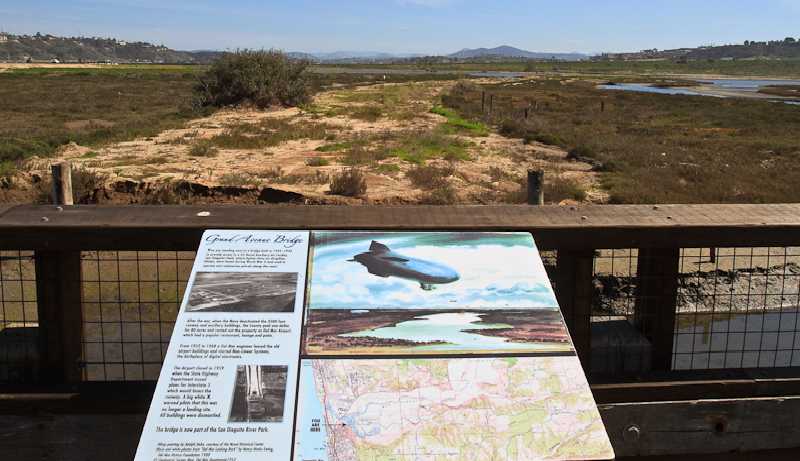
A March 2010 photo by Mark Dossett of a plaque commemorating the history of Del Mar Airport, with the site of the airport in the background. The site of Del Mar Airport is situated at the end of Grand Avenue (known previously as Palm Lane), which is directly off of San Dieguito Drive. The site now includes part of the San Dieguito River Regional Park & a portion of Interstate 5.
Reference
My Series About the KAYPRO
--> Go to Part 1 : Versions
--> Go to Part 2 : Hardware
--> Go to Part 3 : 8K EPROM Modification
--> Go to Part 4 : Formatting a Hard Disk
--> Go to Part 5 : USER areas
--> Go to Part 6 : MASMENU - Master Menu
--> Go to Part 7 : Terminal
--> Go to Part 8 : KayPLUS ROM
--> Go to Part 9 : Advent TurboROM
--> Go to Part 10: Multicopy Plu*Perfect
--> Go to Part 11: Kaypro Family & Company
--> Go to Part 12: Kaypro Design Views
--> Go to Part 13: Micro Cornucopia
--> Go to Part 14: Repairing a Kaypro II
--> Go to Part 15: Kaypro Collections
--> Go to Part 16: Kaypro General
--> Go to Part 17: Kaypro Robie
--> Go to Part 18: MFM-Emulators
--> Go to Part 19: Roadrunner ROM
--> Go to Part 20: Software
--> Go to Part 21: FAQ
--> Go to Part 22: Kaypro Virtual
--> Go to Part 23: Formatting a Floppy Disk
--> Go to Part 24: ROM, EPROM
--> Go to Part 25: Kaycomp